


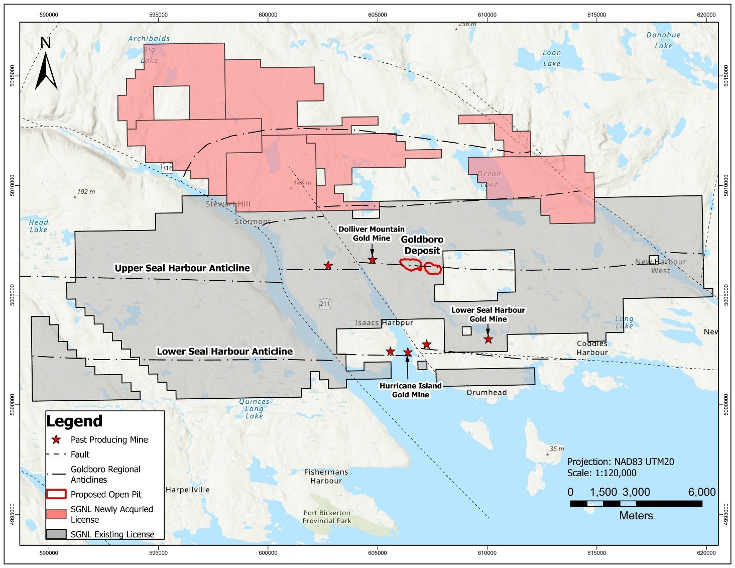
TORONTO, ON / ACCESSWIRE / January 25, 2024 / Signal Gold Inc. ("Signal Gold" or the "Company") (TSX:SGNL) (OTCQX:SGNLF) is pleased to announce that it has further consolidated the Goldboro Gold District, increasing its exploration license area to over 27,200 hectares (~272 km2) surrounding the Company's Goldboro Gold Project in Nova Scotia, Canada ("Goldboro", or the "Project"). This new land position, immediately north of, and contiguous with Goldboro, was acquired through the staking of seven (7) exploration licenses, covering 7,771.2 hectares that covers gold, antimony and tungsten glacial till anomalies (Exhibit A). These anomalous till samples, and associated geophysical targets, have not been previously drill tested and represent additional discovery potential in the Goldboro Gold District.
"While we continue to successfully expand the Goldboro Deposit through drilling and progress permitting for Goldboro, we are also excited to further consolidate such a highly prospective area contiguous with the Goldboro Project in the Goldboro Gold District. The strong tenor of gold anomalies over a large area and coincident antimony and tungsten anomalies points to the potential of this exploration land to host orogenic gold and/or polymetallic skarn mineralization. Signal Gold's greatly expanded exploration land position in the Goldboro area, now at over 27,200 hectares, gives the Company and its shareholders an excellent opportunity for additional discovery adjacent to the significant development-stage project at Goldboro. We believe there is significant potential to discover Goldboro-like deposits within the region, which can leverage the planned mine and mill infrastructure at Goldboro and create a long-term gold mining camp."
~ Kevin Bullock, President and CEO, Signal Gold Inc.
Exploration and Geological Details of Newly Acquired Licenses
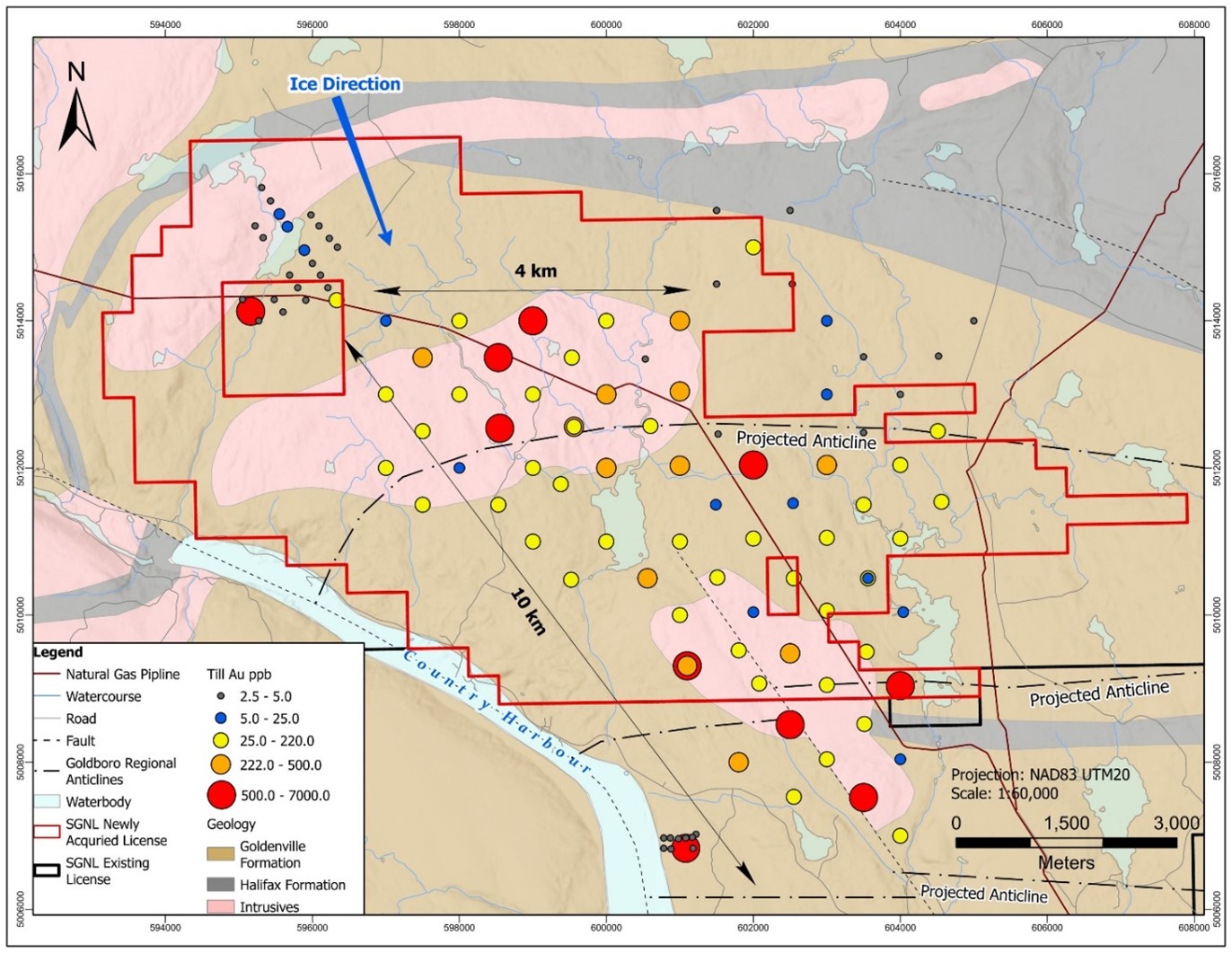
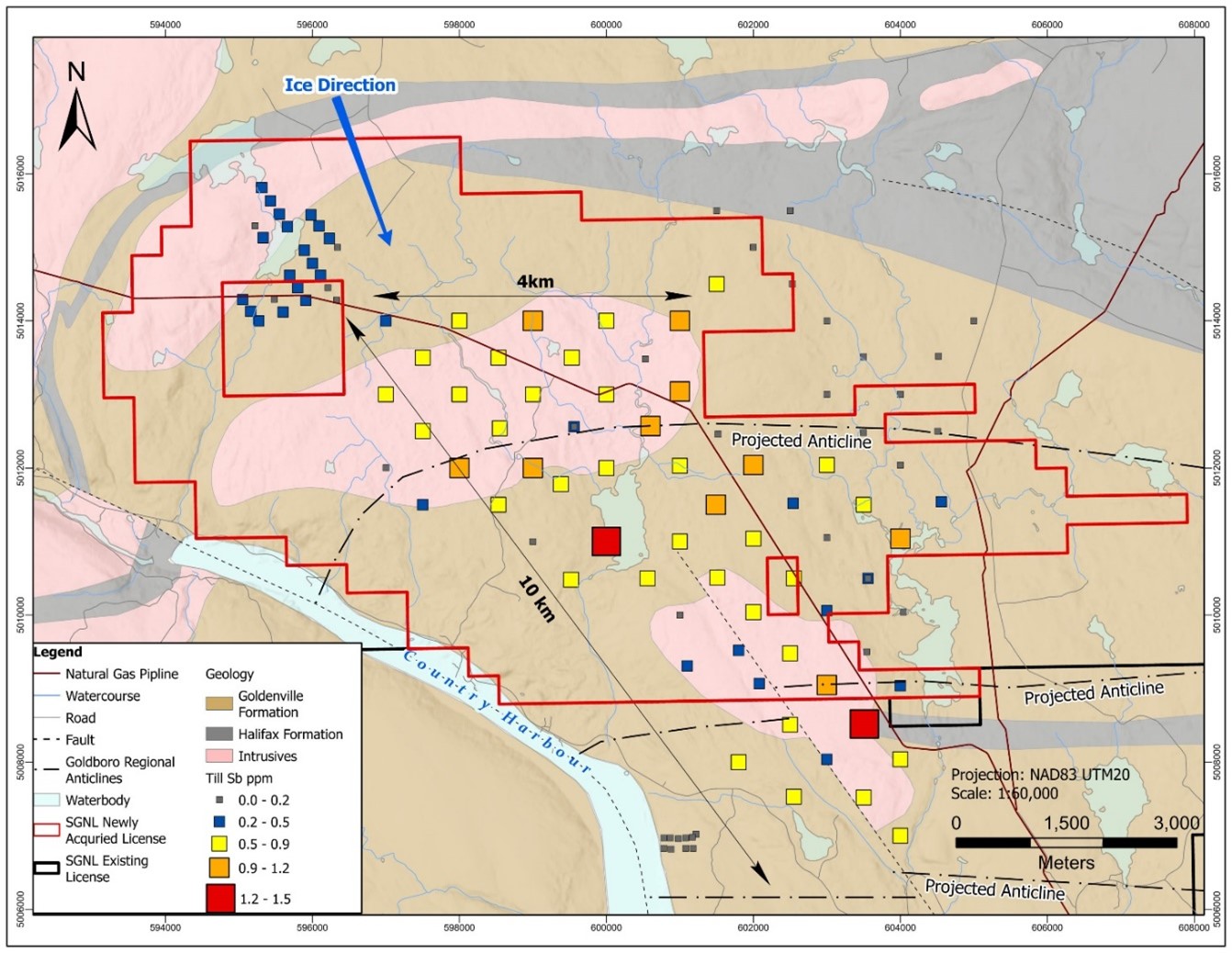
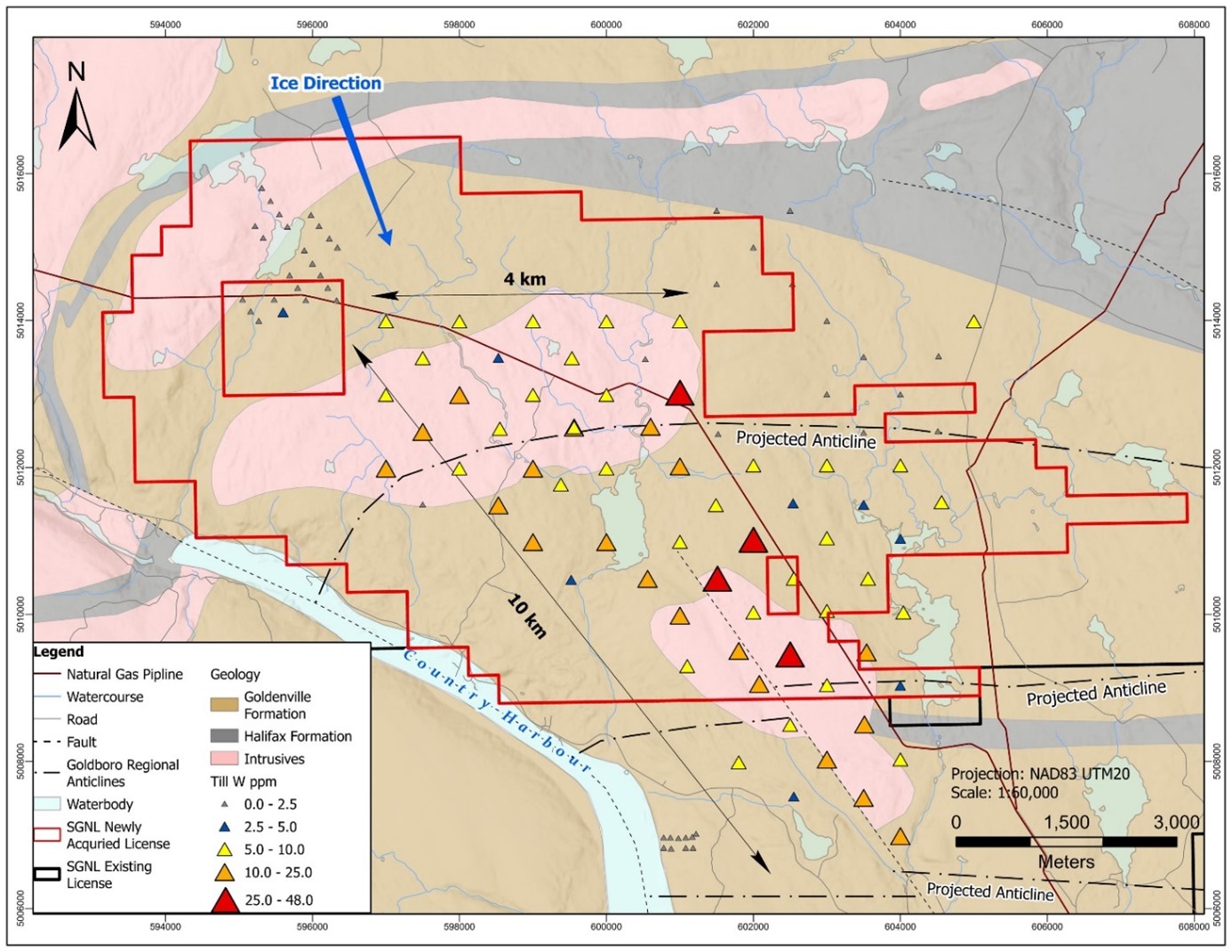
The newly acquired exploration area, known as Stewart Brook, covers an area of historic till sampling from 1986-1988 by Seabright Resources Inc. which defined a combined gold, antimony and tungsten till anomaly over a 10 by 4 kilometre area. Of the 497 historic samples taken within the region, gold in till values ranged from 0 to 7000 ppb gold, with 24 of these samples assaying above 220 ppb gold (95th percentile) of which 20 samples lie within the Project area. Tungsten values range from 0 to 48 ppm, with 26 of these samples assaying above 10 ppm tungsten (95th percentile) of which 18 samples lie within the Project area. Antimony values range from 0 to 3 ppm, with 23 of these samples assaying above 0.9 ppm tungsten (95th percentile) of which 11 samples lie within the Project area (Exhibits B, C, D).
The area, including the zone of anomalous historic tills, is underlain by sedimentary rocks of the Goldenville Group, the same rocks hosting the nearby Goldboro Deposit, that have been intruded by Devonian granites of the South Mountain Batholith (East Branch and Southern Plutons). Rocks have been deformed by upright folding and faulting that make it a favourable environment to host orogenic gold deposits. Furthermore, the presence of younger granites provides a permissible environment for polymetallic (Au, Ag, Sb, W, Sn, Mo, Pb, Zn) skarn mineralization, similar to the East Kemptville (Nova Scotia), Mount Pleasant, Lake George and Sisson Brook deposits (New Brunswick).
The 10 by 4 kilometre gold, antimony, tungsten glacial till anomaly trends southeast and is sub-parallel to the main glacial transport direction. The northern extent of the anomaly coincides with the northern contact between a granite intrusion and the host Goldenville Group sedimentary rocks delineated by an east-west trending magnetic high. This forms a favourable target for follow-up exploration with a known east-west trend along strike length of approximately 4 kilometres (Exhibits B, C, D).
Two of the licenses in the Ocean Lake area are pending issuance by the Nova Scotia Department of Natural Resources and Renewables, which are expected imminently.
Historic till samples referred to in this news release were obtained from digital data made public by the Nova Scotia Department of Natural Resources entitled "DP ME 134, Version 2, 2006. Compilation of Seabright Resources Inc. Till and Soil Geochemical Data by the Nova Scotia Department of Natural Resources over the Meguma Terrane, Nova Scotia, 1986-1989". The Qualified Person has not completed sufficient work to verify these results.
This news release has been reviewed and approved by Paul McNeill, P.Geo., VP Exploration with Signal Gold Inc., a "Qualified Person", under National Instrument 43-101 Standard for Disclosure for Mineral Projects.
ABOUT SIGNAL GOLD
Signal Gold is advancing the Goldboro Gold Project in Nova Scotia, a significant growth project subject to a positive Feasibility Study which demonstrates an approximately 11-year open pit life of mine ("LOM") with average gold production of 100,000 ounces per annum and an average diluted grade of 2.26 grams per tonne gold. (Please see the ‘NI 43-101 Technical Report and Feasibility Study for the Goldboro Gold Project, Eastern Goldfields District, Nova Scotia' on January 11, 2022, for further details). On August 3, 2022, the Goldboro Project received its environmental assessment approval from the Nova Scotia Minister of Environment and Climate Change, a significant regulatory milestone, and the Company has now submitted all key permits including the Industrial Approval, Fisheries Act Authorization and Schedule II Amendment, and the Mining and Crown Land Leases. The Goldboro Project has significant potential for further Mineral Resource expansion, particularly towards the west along strike and at depth, and the Company has consolidated 27,200 hectares (~272 km2) of prospective exploration land in the Goldboro Gold District.
FOR ADDITIONAL INFORMATION CONTACT:
Signal Gold Inc.
Kevin Bullock
President and CEO
(647) 388-1842
kbullock@signalgold.com
Reseau ProMarket Inc.
Dany Cenac Robert
Investor Relations
(514) 722-2276 x456
Dany.Cenac-Robert@ReseauProMarket.com
SOURCE: Signal Gold Inc.
View the original press release on accesswire.com
